ROTM

National Weather Service Great Lakes Portal

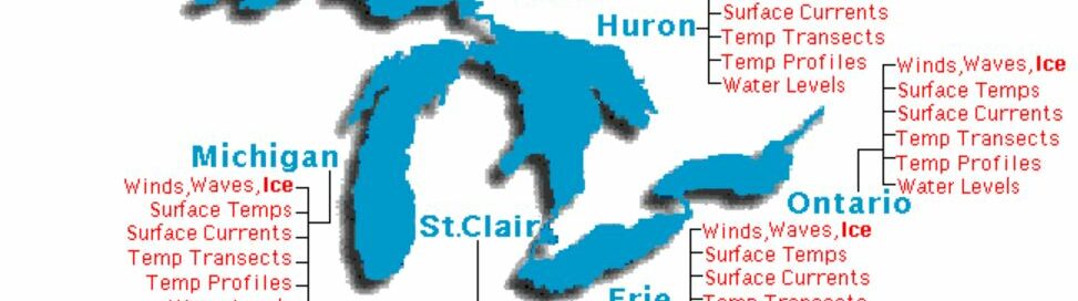
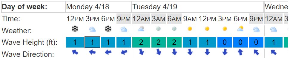
An interactive tool for users to explore detailed weather information.   National Weather Service Great Lakes Portal   Overview The National Weather Service Great Lakes Portal is an interactive tool for users to explore detailed weather information. This tool is hosted by the National Weather Service (NWS), a subset of the National Oceanic and Atmospheric…
Read more

Model Ordinance for Lake Michigan Bluff Setbacks

A document that details an example community zoning ordinance that could help reduce the risk of developments being exposed to coastal hazards.   Model Ordinance for Lake Michigan Bluff Setbacks   Overview The Southeast Wisconsin Regional Planning Commission’s (SEWRPC) Model Zoning Regulations for Lake Michigan Bluff Setbacks is a document that details an example community…
Read more

Living on the Coast: Protecting Investments in Shore Property on the Great Lakes

A description of the Great Lakes coastal environment as well as advice about how to protect coastal investments.   Living on the Coast Protecting Investments in Shore Property on the Great Lakes   Overview Living on the Coast: Protecting Investments in Shore Property on the Great Lakes is a booklet about living and working on…
Read more

Lake Level Viewer

Interactive map used to help users visualize potential Great Lakes water level changes and impacts.   Lake Level Viewer   Overview The Lake Level Viewer is a web-based, interactive map used to help users visualize potential Great Lakes water level changes and impacts. The map allows users to pinpoint areas of concern for flooding and…
Read more

Green Infrastructure Code Audit Workbook

Tool for municipalities to identify codes and ordinances that hinder green infrastructure placement.   Green Infrastructure Code Audit Workbook   Overview The University of Wisconsin Sea Grant’s Tackling Barriers to Green Infrastructure: An Audit of Municipal Codes and Ordinances is a tool for municipalities to use in order to identify codes and ordinances that hinder…
Read more

Great Lakes Water Level Dashboard

Interactive dashboard of monthly water level data for each of the Great Lakes.   Great Lakes Water Level Dashboard   Overview The Great Lakes Water Level Dashboard is an online, interactive dashboard of monthly water level data for each of the Great Lakes. The Dashboard is designed for users to easily examine the fluctuation of…
Read more

Great Lakes Water Level Dashboard

“A multi-agency gateway to long-term, basin-scale hydrological and climatological data for the Laurentian Great Lakes”   Great Lakes Water Level Dashboard   Overview The Great Lakes Water Level Dashboard is a free, online, interactive website that portrays monthly water level information for all the Great Lakes. It is sponsored by the Great Lakes Restoration Initiative…
Read more

Great Lakes High Water Web Page

Compilation of information to help inform decision-making related to Great Lakes water levels.   Great Lakes High Water Web Page   Overview The U.S. Army Corps of Engineers’ (USACE) Great Lakes High Water Web Page is a repository of information compiled to help inform decision-making related to Great Lakes water levels as well as connect…
Read more

Great Lakes Emergency Erosion Control Self Certification

Streamlined temporary erosion control placement authorization process.   Great Lakes Emergency Erosion Control Self Certification   Overview The Great Lakes Emergency Erosion Control Self Certification is a streamlined temporary erosion control placement authorization process intended for emergency situations on Great Lakes shorelines. This process was established by the Wisconsin Department of Natural Resources (DNR) to…
Read more

Great Lakes Coastal Shore Protection Structures & Their Effects on Coastal Processes

Fact sheet discussing types of shore protection and their impacts on coastal processes.   Great Lakes Coastal Shore Protection Structures & Their Effects on Coastal Processes   Overview Great Lakes Coastal Protection Structures & Their Effects on Coastal Processes is a five-page fact sheet that discusses the different types of shore protection and their positive and…
Read more