A review of Great Lakes coastal regulations
Coastal Hazard Regulations in Great Lakes States
A Summary Analysis
Overview
The Association of State Floodplain Managers (ASFPM) Flood Science Center has released a summary analysis of coastal hazard regulations across seven of the Great Lakes states. The report, funded by the Federal Emergency Management Agency (FEMA), summarizes noteworthy coastal hazard regulations that states have enacted including coastal development setbacks, restrictions on shore protection structures, and policies protecting dunes, bluffs, sensitive habitat, and viewsheds.
Key Regulations & Guidance Utilized by Great Lakes States
- Setbacks: an established distance landward of the shoreline (or Ordinary High Water Mark) that regulates where new structures can be placed.
- Model Ordinance:guidance language available for municipalities to adopt into their local ordinances.
- Mapped Coastal Erosion Hazard Areas: maps that delineate the boundaries of erosion hazard areas that may be subject to further regulation.
- Permitting: official authorization for shore protection structures, placement of buildings/structures, etc.
Wisconsin
Since 1968, Wisconsin local governments have had the responsibility of adopting, administering, and enforcing minimum shoreland management regulations. In Wisconsin, the Shoreland Management Act establishes a shoreland zone. The purpose of this zone is to minimize the potential impacts of land development on the area’s surface water and groundwater features. Building and structure setbacks are established to conform to health, safety, and welfare requirements; preserve natural beauty; reduce flood hazards; and avoid water pollution.
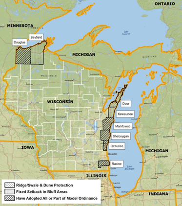
Wisconsin counties with coastal setback regulations (ASFPM Flood Science Center, 2023)
Takeaways
- The adoption of increased setbacks along the Great Lakes coastline reduces the risk to new development in the unincorporated areas of these counties.
- Permitting shore protection structures assures that their construction and operation will minimize damage to property, natural protective features, and other natural resources.
Maps can be used to protect existing natural protective features and nearshore areas critical to maintaining sand transport along the shoreline.
