Data hub that organizes county-level coastal resilience data for more than 850 coastal counties.
NOAA Coastal County Snapshots
Overview
This data hub provided by the National Oceanic and Atmospheric Administration (NOAA) organizes county-level coastal resilience data for more than 850 coastal counties in the United States. Data are gathered from sources including the U.S. Census Bureau, Federal Emergency Management Agency, and National Oceanic and Atmospheric Administration. The data is categorized into three different “snapshots” including Marine Economy, Total Coastal Economy, and Special Flood Hazard. You can navigate through each snapshot by using your scroll wheel or swiping through the page on a touchscreen. Each snapshot contains data associated with each topic displayed charts and maps than can be printed as preliminary economic reports or vulnerability assessments. The data found in each snapshot is described below. At the bottom of each snapshot page, there are additional resources provided to help you develop a more comprehensive economic or flood hazard analysis. The Frequently Asked Questions page provides additional details about how the hub is operated, terminology used in the hub, and where data for each snapshot has come from.
The information found in this hub can be used to ensure safety, protect homes and infrastructure, build coastal economies, and enhance the local environment. The information, visualizations, and reports can be used to help local governments communicate their coastal resilience needs and goals; however, the information can be useful at a larger scale to have a better understanding of the state’s coastal communities as well as at a smaller scale to help provide perspective to property owners about the hazards in their area.
Useful Definitions
As you scroll through the snapshots, you may come across terms such as 100-year floodplain and 6-ft sea level rise. The 100-year floodplain refers to current chances of flooding, whereas the 6-ft sea level rise refers to future flooding possibilities due to climate change. The 100-year floodplain is defined as areas that have a 1% chance of flooding each year. A 100-year flood is defined as a flood event that has a 1% chance of occurring each year. A floodplain is the area impacted, whereas a flood is the event itself.
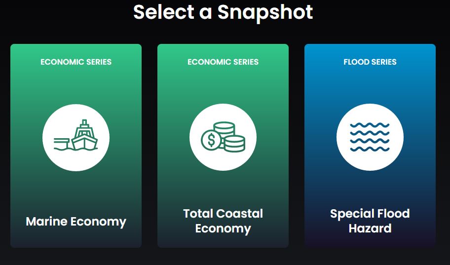
Snapshot Descriptions
Marine Economy
This snapshot contains information pertaining to employment, businesses, wages, and total jobs. As well, the snapshot offers data on businesses at risk of flooding during a 100-year flood or 6-ft sea level rise. This insight into the Marine Economy allows for local municipalities to better plan for the impact on businesses and wages in the case of storms or economic downturn. Economies that are heavily run by the coastal industry are more vulnerable to coastal storms.
Total Coastal Economy
This snapshot contains information pertaining to coastal employment, economic diversity, businesses at risk of flooding, wages and total jobs. This snapshot is different from the Marine Economy in that this snap. This snapshot analyzes the total economy along the coast, including stores, banks, local governments and more. Whereas, the Marine Economy snapshot focuses on strictly Marine industries, including fisheries, construction, tourism and more. This broader view can be used to better understand the diversity of the economy. More diversity can protect the local economy in the case of economic downturn.
Special Flood Hazard
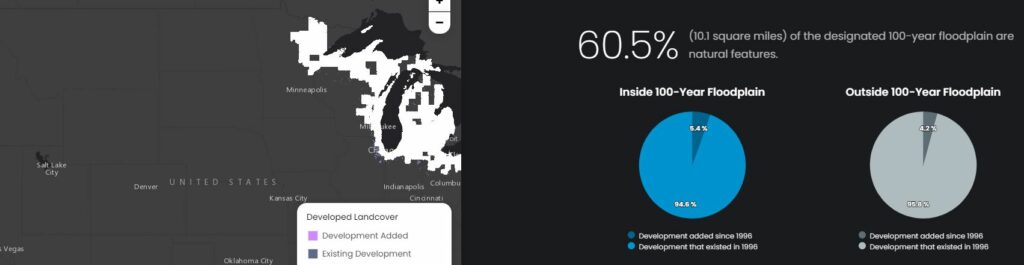
This snapshot contains information pertaining to people, facilities, homes, and businesses at risk of flooding during a 100-year flood or a 6-ft sea level rise. Additionally, the snapshot contains a percentage of the 100-year floodplain that is made up of natural features. The higher this percentage is, the better. When a floodplain is made up of natural features, these features help diminish the chance of flooding. For example, features such as wetlands act as a natural sponge that can “soak up” and clean the water in the environment. Below is a screenshot of the natural features portion of this snapshot.
Check it out for yourself here.
