Updated flood risk maps for the Great Lakes coasts.
New FEMA Special Flood Hazard Areas for Lake Michigan Coastal Communities
Overview
Severe flood events can happen along the Lake Michigan coast when strong winds drive Lake water and waves on shore. FEMA has been rolling out new floodplain maps for several counties along the Lake Michigan coast that identify areas at high risk for coastal flooding. New coastal Special Flood Hazard Areas (SFHA) are identified on the maps using the following flood zone designations.
- Zone VE are coastal high-hazard zones where wave action and/or high-velocity water can cause structural damage during the 1-percent-annual-probability flood. Wave height or wave runup is expected to be greater than or equal to 3 feet in these zones. Base flood elevations (BFEs) are assigned on the new floodplain maps.
- Coastal Zone AE are areas subject to lower wave energy or inundation by the 1-percent-annual-probability flood. Wave height or wave runup is expected to be less than 3 feet in these areas.
- Zone AO are areas of special flood hazard having shallow water depths and/or unpredictable flow paths between 1 and 3 feet. These zones often appear to the landward side of a VE zone where waves overtop a bluff or coastal structure – also known as the overtopping “splash zone.”
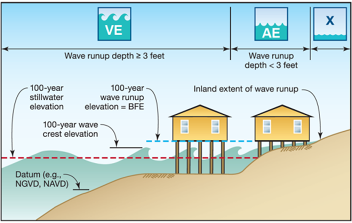
Coastal Special Flood Hazard Areas (FEMA)
Maps that include new coastal flood zones are final, or “effective,” in four of Wisconsin’s Lake Michigan coastal counties. FEMA has issued (or is expected to issue) Letters of Final Determination (LFD) for six additional Wisconsin Lake Michigan coastal counties stating that there are new or updated flood insurance rate maps (FIRMs) for these areas. The receipt of the LFD starts a 6-month adoption phase by which cities, villages, and counties must update their floodplain ordinances to remain in good standing with the National Flood Insurance Program (NFIP). The table below provides the date of the LFD and the effective date of the new floodplain maps for each of Wisconsin’s Lake Michigan coastal counties.
Whenever new floodplain maps are released, properties may be included in the SFHA for the first time and lenders may require these properties to obtain flood insurance policies. For further information related to coastal SFHA and Flood Zones, see the Great Lakes Coastal Flood Study. In addition, the Wisconsin Department of Natural Resources offers assistance with drafting of floodplain ordinances for communities free of charge. Communities interested in assistance can reach out the WDNR at DNRFloodplain@Wisconsin.gov .
| County | Status |
| Manitowoc | Effective date February 23, 2023 |
| Oconto | Effective date March 21, 2023 |
| Brown | Effective date May 9, 2023 |
| Racine | Effective date January 11, 2024 |
| Kenosha | LFD Oct. 11, 2023, effective date April 11, 2024 |
| Door | LFD Nov. 8, 2023, effective date May 8, 2024 |
| Ozaukee | LFD Jan. 31, 2024, effective date July 31, 2024 |
| Kewaunee | Expected LFD Feb. 28, 2024, effective date Aug. 28, 2024 |
| Sheboygan | Expected LFD Feb. 28, 2024, effective date Aug. 28, 2024 |
| Milwaukee | Expected LFD April 24, 2024, effective date Oct. 24, 2024 |
| Marinette | Draft maps expected 2025/2026 |
