2022

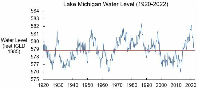
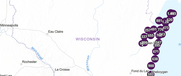
Updated: Wisconsin Shoreline Inventory & Oblique Photo Viewer

A web-based, interactive map of Wisconsin coastal data that enables users to visualize the temporal changes to Wisconsin’s shorelines.   Wisconsin Shoreline Inventory & Oblique Photo Viewer Featuring NEW photos from 2022   Overview The Wisconsin Shoreline Inventory and Oblique Photo Viewer is a web-based, interactive map of Wisconsin coastal data that enables users to…
Read more

Introducing: Wisconsin Sea Grant

Wisconsin Sea Grant supports coastal resilience through research, outreach, and education.   University of Wisconsin Sea Grant Institute   Who Are They? Sea Grant is a federal-university partnership between the National Oceanic and Atmospheric Administration (NOAA) and university-based programs in each U.S. coastal state as well as Puerto Rico and Guam. The Sea Grant network…
Read more

August 2022 Water Level Update

Lake Michigan water levels have peaked for the season, with 0 inches of change from July to August. Though Lake Michigan is now about 24 inches below the highest monthly water level recorded for August in 2020, the Lake is still about 9 inches above the long-term average water level. Water levels are expected to…
Read more

Science Communications Toolkit

A series of one-page documents to help students and researchers communicate with a variety of audiences.   Science Communications Toolkit   Overview of the Toolkit  The Science Communications Toolkit is a series of twenty, one-page documents to help students and researchers communicate with a variety of audiences. While the stated audience is students and researchers, these…
Read more

July 2022 Water Level Update

  Lake Michigan water levels have now peaked for the season, with 0 inches of change from June to July. Though Lake Michigan is now about 25 inches below the highest monthly water level recorded for June in 2020, the Lake is still about 9 inches above the long-term average water level. Water levels are expected…
Read more

Equitable Community Resilience Adaptation Toolkit

Online toolkit providing resources and guidance on integrating equity into climate resilience planning.   Equitable Community Resilience Adaptation Toolkit   Visit the Equitable Community Resilience Adaption Toolkit here    Overview The Equitable Community Resilience Adaptation Toolkit provides resources and guidance on integrating equity into climate resilience planning. The toolkit uses a four-step framework for creating…
Read more

CALM Logo

June 2022 CALM Network Meeting Summary

Meeting summary for the June 2022 CALM Network held virtually on June 22, 2022.   June 2022 CALM Network Meeting Summary   The Collaborative Action for Lake Michigan (CALM) Coastal Resilience network meeting was held virtually on June 22, 2022. CALM is a network for communities along Wisconsin’s entire Lake Michigan coastline working to increase…
Read more

ReduceFloodRisk.org

Interactive tool helping property owners understand their flood risk and select appropriate risk reduction strategies.   Reduce Flood Risk   ReduceFloodRisk.org Reduce Flood Risk is a new, interactive flood mitigation resource library from the Association of State Floodplain Managers (ASFPM). This tool is designed to help property owners, particularly those in flood-prone areas, understand their…
Read more

June 2022 Water Level Update

Lake Michigan water levels continue their seasonal incline, increasing by 3 inches from April to May. Though Lake Michigan is now about 25 inches below the highest monthly water level recorded for May in 2020, the Lake is still about 10 inches above the long-term average water level. Water levels are expected to continue their…
Read more

April 2022 Water Level Update

 Lake Michigan water levels have started their seasonal incline this spring, increasing by about 5 inches from March to April. Though Lake Michigan is now about 26 inches below the highest monthly water level recorded for April in 2020, the Lake is still about 9 inches above the long-term average water level. Water levels are…
Read more