There was a need for a shoreline stabilization project to protect and Oak Creek bluff from erosion, create habitat, and provide safe public access to the shoreline.
Oak Creek Shoreline Resilience, Habitat, & Access
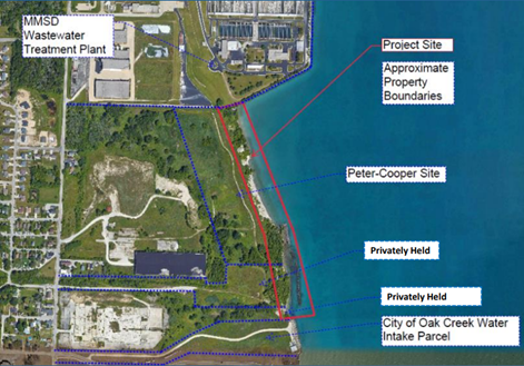
Property locations and names (Photo: City of Oak Creek/Edgewater Resources)
Overview
The City of Oak Creek (the City) wanted to slow erosion at coastal bluff on the Peter-Cooper brownfield site. Slowing bluff erosion is a critical step in the site’s transformation into a public park. Continued erosion of this bluff would release legacy industrial contamination into Lake Michigan and threaten the adjacent wastewater treatment plant and drinking water intake. The City had developed an initial design for erosion control but needed a more detailed design to be competitive for construction funding. This project created the final design and engineering for bluff toe protection, bluff slope revegetation, and new public access at the site. With final design documents complete, the City is now seeking funding for construction.
This project was funded as part of the Southeastern Wisconsin Coastal Resilience project led by the Wisconsin Coastal Management Program. To be eligible for this funding, Lake Michigan coastal local governments in Kenosha, Racine, Milwaukee, and Ozaukee counties completed a Coastal Resilience Self-Assessment to help prioritize top coastal hazard concerns and identify potential planning and mitigation practices to address these hazards. Local governments used the results of their assessment to develop projects that would help address priority needs identified in the assessment in order to enhance their capacity to plan, prepare for and adapt to coastal hazards.
Funding for this project was provided by the National Atmospheric and Oceanic Administration (NOAA) Coastal Resilience Grants Program, Grant # NA17NOS4730144.
Title of Project: Oak Creek Shoreline Resilience, Habitat, and Access Project
Organization applying: City of Oak Creek
Total project cost: $81,000
Grant award: $50,000
Coastal Resilience Self-Assessment Summary
The City of Oak Creek (the City) completed the Coastal Resilience Self-Assessment, a tool intended to help communities prioritize their top coastal hazard concerns (Part 1) and consider actions to increase the coastal resilience of their community (Part 2). The self-assessment served as a starting point identify opportunities to address coastal hazard issues.
Part 1: Identifying Coastal Hazard Risk – A matrix tool used to prioritize coastal hazard issues in a community based on rating: (1) frequency of occurrence, (2) impact to the community, and (3) level of preparedness.
The top hazards of concern identified by the City were shoreline recession, bluff failure, shoreline protection structure damage, and pollutant pathways from legacy industrial sites. All four hazards were rated to have a high probability of occurrence, moderate-to-high impacts on the community, and low levels of preparedness, leading these to be deemed as high-priority coastal hazards to address.
Part 2: Resilient Practices Questionnaire – A series of yes/no questions used to help identify common planning and mitigation actions that the community can implement to address coastal hazard issues, including planning, zoning, education, and construction actions.
The following questions led the City to consider resilience actions.
Question 3: Are there any estimates of the future financial losses that may result from coastal hazards, including loses to private property, public property, infrastructure, and utilities?
The City has been losing public property at the Peter-Cooper site to bluff recession due to wave erosion. This bluff recession will eventually “flank”, or erode around the edges of the property. This flanking erosion could damage the shoreline of the Milwaukee Metropolitan Sewerage District (MMSD) Southshore Wastewater Treatment Plant to the north and the Oak Creek Water Intake Structure to the south. Two adjacent privately owned parcels to the south are also experiencing similar bluff recession issues.
Question 26: Are you aware of instances where shore protection structures adversely impacted adjacent shorelines?
The Peter-Cooper site is located between large shore protection structures to the north and south. These structures block sediment transport along the shore and “starve” the beaches at the bluff toe of sand. Without enough sand, the narrow beach at the bluff toe only offers limited wave protection to the bluff.
Question 27: Does your community consider hybrid-structural options (nature-based, living shoreline, or engineering with nature approaches) or non-structural options (slope stabilization, vegetation, beach nourishment, or asset relocation)?
The City of Oak Creek Engineering Department is interested in using nature-based protection to deal with the shoreline recession, add habitat, and improve the aesthetic for the public. Doing so would complement the existing habitat improvements at the City’s nearby Lake Vista Park.
The Coastal Resilience Issue
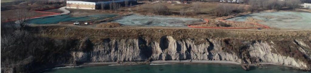
The City-owned parts of the bluff and shoreline are located within a 250 acre shoreline brownfield site. This brownfield contains legacy industrial contamination, including metals and polycyclic aromatic hydrocarbons (PAHs). The bluff toe has experienced a large amount of wave erosion in recent years. In the 1960s, a seawall was built directly north of the project area, blocking sediment transport and starving the beach of sand. The narrow beach leaves the bluff toe more vulnerable to wave erosion. The high lake levels from 2019-2021 led to accelerated erosion of the bluff. Drone imagery was used to track these changes and compare with historic photos from the Wisconsin Shoreline and Oblique Photo Viewer. It is anticipated that damaging events will continue to occur in the future, possibly increasing the severity due to climate change.
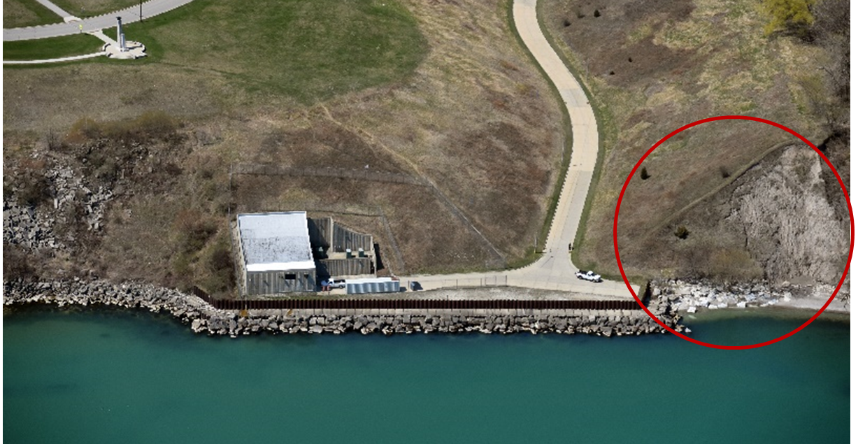
The Oak Creek Water Intake Structure, with erosion flanking the north end of the site (red circle). (Photo: Capt. Dennis Carr)
Continued erosion of the bluff will make the legacy contaminants in the bluff’s soil vulnerable to erosion into Lake Michigan. Preventing these legacy contaminants from eroding into Lake Michigan is important for protecting water quality of nearby habitat and the drinking water source for Oak Creek, Franklin, and part of Caledonia because the Oak Creek Water Intake Structure borders the south end of the bluff. Bluff erosion has also limited options for safe access to the shoreline. These issues previously prevented the site from being developed into a new Bluff Top Ribbon Park.
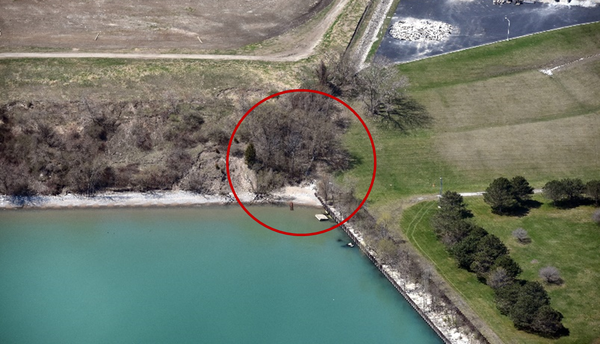
Flanking erosion could occur at the end of the MMSD treatment plant’s seawall. Red circle indicates that location.
(Photo: Jeremy Craven, Edgerton Contractors)
The adjacent shorelines north and south of the City’s Peter-Cooper site are also at risk of erosion. A MMSD treatment plant is to the north and has a seawall that abuts the site. If the City-owned bluff continues to recede, erosion may begin “flank” around the end of the seawall and eventually impact the treatment plant. To the south of the Peter-Cooper site are privately owned bluff parcels. A breakwater protected this area of the bluff at lower lake levels. As the lake levels rose, the breakwater was submerged and no longer dissipated the energy of the incoming waves. Between 2018-2020 there was significant new bluff toe erosion at these two sites. To the south of the Connell site, the Oak Creek Water Intake Structure is at risk to flanking erosion if recession of the bluff continues.
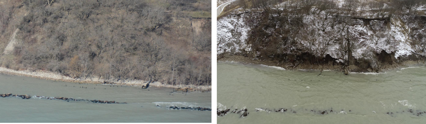
Offshore breakwater visible with no bluff toe erosion in April 2018 (left) and offshore breakwater mostly submerged with significant bluff toe erosion that removed the stone beach and luff toes in January 2020 (right) (Photo: Jeremy Craven, Edgerton Contractors)
Vision for the Community
The City wants to slow erosion of the bluff to prevent the release of legacy contamination, protect critical infrastructure, and create a public park so the community can safely access this area of Lake Michigan shoreline for the first time in over 80 years.
The Need
There was a need for a final design for shoreline stabilization to protect the bluff from erosion, create habitat and provide safe public access to the shoreline. Previously, the City had obtained grant funding from the Fund for Lake Michigan to develop an initial design and begin the permitting process with the Wisconsin Department of Natural Resources (WDNR). This initial design helped obtain permits, but the City had budget constraints that hindered them from construction without outside funding assistance. A detailed plan set and technical specification documents were needed to make the City more competitive when seeking funding for construction.
Collaborators
- The City of Oak Creek (the City)
- Edgewater Resources – Consultant Engineering Firm
- Edgerton Contractors, Inc – Oak Creek based Construction/Engineering Firm
- Milwaukee Metropolitan Sewerage District (MMSD)
- Adjacent Private Parcel Owners
- Fund for Lake Michigan
- Wisconsin Department of Natural Resources (WDNR)
- Remediation and Redevelopment Bureau
- Shoreline and Water Resources Bureau
- United States Army Corps of Engineers (USACE)
- Milwaukee County
What was accomplished
The City hired Edgewater Resources, a coastal engineering consulting firm, to design the shoreline stabilization. The design includes the construction of a revetment at the bluff toe and buttress fill with clean material and a drainage layer at the bluff face to stabilize the bluff slope. Final design documents included a basis of design memorandum, construction-level plan set, and construction-level technical specifications. The memorandum included details on wave modeling, site geotechnical factors, groundwater conditions, and other technical considerations in the design. The plan set provided detailed construction-ready drawings. The specifications describe the details of site demolition, earthwork, revetment construction, and site access.
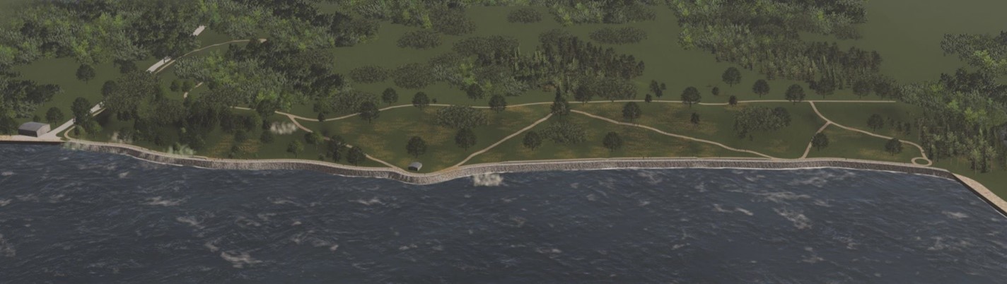
Rendering of the final project design (Photo: City of Oak Creek/Edgewater Resources)
Revetment Design
A revetment was chosen to limit wave erosion at the base of the bluff. A revetment is a sloped structure of large armor stone. Nature-based toe protection options like beaches were also explored. However, high wave environment and sediment starvation at the site made these options impractical. The revetment was designed to withstand a combination of 50-year return period water levels (i.e. a 2% chance of occurring in a year) and 50-year return period wave conditions (i.e. a 2% chance of occurring in a year). The 2,200 foot long revetment will be built from the seawall at the MMSD treatment plant to the existing revetment at the water intake site. This includes construction on the two privately-owned parcels south of the Peter-Cooper site. A contiguous revetment across multiple properties that ties into existing shore protection structures will mitigate the effects of flanking erosion. More details on this public/private partnership can be found in the “Partnerships Reinforced or Made” section.
Bluff Regrading and Public Access Design
The bluff slope will be regraded with fill to create a stable slope. Due to wave erosion, portions of the bluff are currently very steep. Regrading to a stable slope will mitigate bluff collapse and allow public access. The proposed design will use clean fill to construct a gentle 3-to-1 slope. Fill was chosen over “cutting back” the slope to leave the contaminated bluff soil undisturbed. A site investigation also revealed groundwater seeping out of the bluff, which can cause stability issues. A groundwater drainage system was designed to drain this seeping water from between the existing bluff and the newly placed fill. A two-foot thick soil barrier will be placed on the regraded bluff face to create a buffer between the surface and underlying contaminated material. Grasses and shallow-rooted vegetation will then be planted to stabilize the soil. A revegetated bluff will also provide new coastal habitat on the former industrial site. People will be able to access the bluff via walking paths. The main walking path down the bluff will also act as a surface water interceptor to prevent erosion from water flowing down downhill. There also will be an ADA-accessible path.
As part of the conversation regarding public access, the City has reached an agreement with both the private parcel owners to acquire the bluff face, and a small portion of the upland directly adjacent to the bluff. This will assure public access in the future, and helps fulfill the Public Trust Doctrine requirement for the WDNR water quality certification (permit) to build this important project.
Partnerships Reinforced or Made
This project reinforced the City’s collaborative relationship with regulatory agencies. The City initially discussed the need for the project and proposed a technical approach via conference calls and visual presentations with the WDNR and USACE. After the USACE determined the WDNR would take regulatory jurisdiction, the City then focused their relationship-building towards the WDNR Remediation and Redevelopment Bureau and the Shoreline and Water Resources Bureau. Good communication helped address questions and concerns about the project early in the permitting process.
The City also developed collaborative relationships with MMSD and the two private parcel owners. The City’s shoreline abuts the MMSD treatment plant and the privately-owned land. Building relationships with all three stakeholders led to cooperative collaboration on this project and future endeavors. MMSD expressed support of this project and signed an agreement with the City to provide $583,858 in future implementation funding because of the threat of flanking erosion at the end of its seawall if the bluff continues to recede. The two private parcel owners agreed to include their parts of the bluff in the project after the City explained how this work would help incentivize redevelopment and slow bluff erosion for their parcels. As the collaboration continued, the private parcel owners and City reached an agreement for the City to acquire the bluff face and a portion of the adjacent upland, which will assure public access in the future, as well as assure coordinated project implementation. By coordinating shore protection with adjacent landowners, the threat of flanking erosion will be mitigated to all of these properties.
Going Forward
The City will use the final design documents to seek funding to construct the shoreline protection structure, bluff stabilization, coastal habitat, and public access trail. Completed “shovel ready” final design and specifications allows the City to be more competitive when applying for funding.
Additionally, the City will continue to develop the public/private relationship with the two private parcel owners, who remain important partners due to being adjacent to the project, and MMSD. Coordinating and sharing information with the private parties and MMSD will be key to sustaining this collaboration.
Once this engineering solution to the bluff erosion is constructed, the City will be able to develop the site into a blufftop park. Future efforts could include adding more public amenities and access to the water’s edge.
Lessons Learned
- Communication with regulatory agencies at the beginning stages of a project is important to a productive permitting process.
- Shoreline images (captured by drone or airplane) and shoreline change monitoring data are powerful tools to illustrate the need for action to decision makers, partners and regulators.
- A coordinated approach to addressing shoreline erosion was initiated through communication and information sharing with the neighboring private parcel owners. The resulting public/private partnership will mitigate flanking erosion along this entire stretch of shore.
- Translating technical concepts into plain language gives all partners a greater understanding of the project, leading to a higher likelihood of success.
- Technical information about the impacts of waves, soil type, and groundwater levels are critical to ensuring the project is well-designed and will have a successful implementation.
