The City of Racine Public Health Department undertook a project to better understand coastal hazard impacts through local ordinance review, parcel mapping, shoreline classification, and public outreach.
City of Racine Coastal Resiliency Assessment
Overview
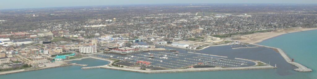
Like many areas along the Great Lakes Coast, public and private properties in Racine are experiencing increased erosion and flooding due to fluctuating water levels on Lake Michigan. The City of Racine Public Health Department (the Health Department) wanted to better understand and proactively mitigate adverse coastal impacts. To do so, the Health Department undertook a project to identify potential threats to public and private property, infrastructure, and utilities; develop and leverage coastal hazard education and outreach materials for shoreline property owners; and review ordinances and regulations for Racine County jurisdictions to evaluate if they aligned with current standards and identify opportunities to better address coastal hazards.
This project was part of the larger Southeastern Wisconsin Coastal Resilience project, which provided funding to Lake Michigan coastal local governments in Kenosha, Racine, Milwaukee, and Ozaukee counties to address priority coastal hazard issues identified in a Coastal Resilience Self-Assessment. This project was funded by the Wisconsin Coastal Management Program and the National Oceanic and Atmospheric Administration, Office for Coastal Management, Grant # NA17NOS4730144
Organization applying: City of Racine Public Health Department
Total project cost: $42,556.67
Grant award: $20,9992.00
Coastal Resilience Self-Assessment Summary
The Health Department, in partnership with Racine County, completed the Coastal Resilience Self-Assessment, a tool intended to help communities weigh the effects of various coastal hazards (Part 1) and consider planning and mitigation actions which may increase their coastal resilience (Part 2). Below are some highlights from their self-assessment that guided the development of their project.
Part 1: Identifying Coastal Hazard Risks
The top hazard of concern identified in the matrix tool was a tie between Shoreline Recession/Bluff Failure and Coastal Flooding.
Part 2: Resilient Practices Questionnaire
The following questions led the City of Racine to consider resilience actions.
Question 2: Do updated maps or spatial data exist that identify areas at risk to coastal hazards?
To determine areas in Racine that are at highest risk to coastal hazards, a top priority emerged to determine what coastal assets were under the jurisdiction of the city, county or held privately. This information is critical to assess and plan for the potential economic, environmental, and social impacts of coastal hazards in the city.
Question 24: Are ordinances pertaining to coastal hazards consistent with those of surrounding jurisdictions in both policy and language?
Racine’s coastal setback ordinance, which helps to reduce the risk of coastal erosion to new development, was last modified in the 1980’s. A priority emerged to ensure that coastal ordinances for the City of Racine and neighboring jurisdictions are consistent with the latest model ordinances.
Question 20: Does the community have coastal hazard information such as maps and guidance on shoreline management practices available or accessible to residents upon request?
To support coastal residents dealing with ongoing coastal erosion, Racine recognized a need to make education and outreach materials readily available for owners of privately held assets.
The Coastal Resilience Issue
Public and private properties in Racine are exposed to development pressures as well as coastal hazards including storm events, stormwater runoff, flooding, fluctuating water levels, and erosion. Changing climate conditions will continue to influence these hazards over the coming decades, posing an ongoing risk to life and property.
The Need
There is a need to proactively address these coastal challenges through long-term planning efforts and municipal ordinances to help communities become more resilient preceding a disaster and expedite recovery in post-disaster situations.
The Health Department and Racine County determined that updated parcel maps were needed to identify potential threats to public and private property, infrastructure, and utilities. New maps would aid the municipalities of Racine County in developing coastal hazard vulnerability plans. Additionally, the need for consistency in ordinances pertaining to coastal hazards from jurisdiction to jurisdiction within Racine County was identified through the self-assessment.
Vision for the Community
To reduce risk to public and private property and infrastructure, and to better understand, withstand, and proactively respond to adverse impacts of coastal hazards.
Collaborators
- Racine County
- Racine County Emergency Management
- City of RacinePublic Health Department
- Village of Wind Point
- Village of Caledonia
- Village of North Bay
- Village of Mount Pleasant
- Southeastern Wisconsin Regional Planning Commission
- Wisconsin Coastal Management Program
- Wisconsin Sea Grant
What Was Accomplished
This project began in May of 2019. There were three main components to this project (1) zoning ordinance review, (2) erosion risk data mapping, and (3) site assessments.
Zoning Ordinance Review
A review of ordinances and regulations for coastal Racine County jurisdictions was conducted to evaluate if they aligned with current standards and identify opportunities to better address coastal hazards. Zoning ordinances from the Village of North Bay, Village of Wind Point, Village of Mount Pleasant, City of Racine, and Racine County were analyzed. The review identified current language in the ordinances that positively or negatively impacts shoreline resiliency. It also compared existing ordinances to model ordinances. In addition to the review of local ordinances, zoning ordinances from other parts of the United States were reviewed to identify language and practices that have successfully promoted coastal resilience.
A Municipal Ordinance Review and Audit Tool was developed in conjunction with the zoning ordinance review. It allows communities to compare their existing ordinances against model ordinances with exemplary language explicit in addressing coastal resiliency and responding to shoreland development.
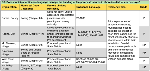
Municipal Ordinance Review and Audit Tool (credit: City of Racine)
Erosion Risk Data Mapping
The Health Department determined that mapping the coastline would be essential for evaluating the vulnerabilities and trends in bluff recession. The Wisconsin Shoreline Inventory and Oblique Photo Viewer was used to view bluff conditions, existing shore structures, and short- (29-year) and long-term (59-year) recession rates for both the bluff toe and crest.
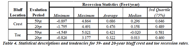
Coastal bluff vulnerability maps were created using short-term recession rates, long-term recession rates, and high-resolution imagery from the Photo Viewer. These maps include a visual representation of bluff condition assessments and recession data, as well as ancillary information such as parcel ID’s, zoning and land use, bluff condition, and bluff crest/toe recession rates.
Additionally, coastal bluff variation maps were created. These maps assessed bluff changes within a 59- and 20-year period including movement of the bluff toe and crest. These maps also depicted where infrastructure is placed along the shore including homes/buildings, erosion protection structures, and land use type. An example of the 20-year Recession and Bluff Condition map is shown below.
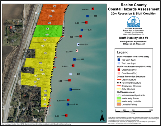
Bluff erosion rate maps (credit: City of Racine)
Site Assessments
On-the-ground site assessments of private and public properties augmented the oblique aerial observations performed in the erosion risk data mapping portion of the project. A letter was sent to private property owners to gauge their interest in a site assessment and request permission for property access. The site visits included an examination of bluff conditions and identification of existing erosion mitigation practices. In total, 56 private property and 14 public property site assessments were completed in November and December of 2019.
Public Outreach
Due to the COVID-19 pandemic, opportunities to conduct public outreach were limited. The Health Department utilized the site assessments as engagement opportunities to better understand what types of coastal management resources property owners needed. As a result, the guide was created to help property owners with recognition, management, and mitigation of coastal hazards resulting from changing climate conditions and Lake Michigan water levels. This guide is divided into three sections: (1) Great Lakes Water Levels, Erosion, and Flooding, (2) Coastal Protection, Community Planning, and Climate Change (3) Municipal Codes, State Law References, and Model Communities. Each section includes links to tools, ordinances, contacts, and best practices that property owners can access to become more informed on coastal processes and management.
This project took 16 months to complete and wrapped up in September of 2020. The parcel maps and ordinance reviews were sent to each of the participating municipalities for their review. Materials were updated based on comments the Health Department received from these communities. The Racine County Coastal Resiliency Assessment and the Municipal Ordinance Review and Audit Tool were distributed to Racine County, the 12 coastal municipalities in Racing County, the Southeastern Wisconsin Regional Planning Commission, and Racine County Emergency Management.
Going Forward
The work of this project was documented in the . Several key recommendations include:
- Encourage legislative action at the state and federal level to provide financial assistance to coastal property owners.
- Establish a countywide program that educates and offers financial incentives to encourage property owners to vegetate bluff faces and shoreline abutting portions of coastal properties with native plants to improve soil stability and drainage.
- Encourage development of coastal erosion risk maps alongside existing FEMA flood insurance rate maps, that can be utilized by the public for real estate transactions and government officials for policy decisions.
The Health Department distributed the Coastal Management and Educational Resources for Private Property Owners guide during one-on-one interactions with coastal property owners. Health Department staff continue to share these educational materials with property owners as they contact the department about their coastal management needs and inquiries.
This project created a foundation for science-based, informed coastal hazard decision-making through the assemblage of a comprehensive resource list, drawn from local, state, regional and federal sources. Staff capacity and ongoing needs to repair damages caused by coastal hazards can be a challenge to implementing the recommendations from this project. However, the City continues to identify opportunities to implement resilient practices on public parcels.
Partnerships Reinforced or Made
A multitude of partnerships were created and reinforced throughout this project including a direct cooperative effort between the Wisconsin Coastal Management Program, Wisconsin Sea Grant Institute, and the City of Racine to determine project needs and provide funding. Input from the Southeastern Wisconsin Regional Planning Commission, Racine County Emergency Management, and the Southeastern Wisconsin Coastal Resilience Community of Practice Network was sought to help develop comprehensive public education and outreach materials to encourage informed decision making. Additionally, Racine County municipalities including the Town of Caledonia and Villages of Mount Pleasant, Wind Point and North Bay participated in the comprehensive zoning ordinance reviews.
Lessons Learned
- Tracking and reporting the condition of shore protection structures as well as damage from coastal hazards can be used to support the use of municipal bonds (or similar measures) to support shoreline protection and preservation projects.
- It is beneficial to maintain detailed records of maintenance and improvements at public locations (including plans for engineered solutions, before/after pictures, and maintenance summaries of tasks completed at locations).
- Documentation of parcel ownership, on the ground photos, and physical site assessments all provided a wealth of information from which to formulate future coastal resiliency projects.
