Coastal Resilience Community Impact Project
Overview
The Coastal Resilience Community Impact Project assists municipal and county staff in communities along the western coast of Lake Michigan to develop adaptation and resilience strategies to respond to flooding, erosion, and related climate change driven hazards.
Goal
Support coastal communities’ response to the impacts of climate change and resulting lake level changes.
Focus Area
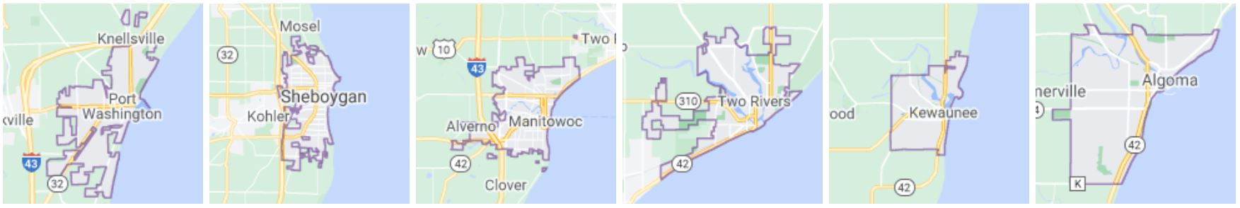 Western coast of Lake Michigan:
- Port Washington
- Sheboygan
- Manitowoc
- Two Rivers
- Kewaunee
- Algoma
Project Components
- Workshops: Training workshops that focused on (1) the challenges of precipitation changes on communities; (2) steps to resilience planning; and (3) practical tools for resilience implementation such as green infrastructure, innovative technologies and financing, and municipal code and water stewardship audits.
- Community Meetings: One-on-one meetings to assess overall needs, share resources, prioritize projects, help to design and implement resilience planning frameworks, and align projects with potential funding.
- Prioritized Project Lists: Working with communities to develop a list of prioritized projects, identify funding opportunities, and draft grant applications.
Coordinating Organizations
- Lakeshore Natural Resource Partnership
- Water365
Visit the Coastal Resilience Community Impact Project Website
Coastal Hazards of Superior
Overview
Coastal Hazards of Superior (CHAOS) is a community of practice for Minnesota and Wisconsin’s Lake Superior coastlines. CHAOS is a platform for engaging local community leaders, managers, researchers, and communicators with a shared concern about coastal hazards and their impacts.
Goal
CHAOS aims to help build strong collaborations between those impacted by coastal hazards and those with resources to study, address, or mitigate impacts.
 Focus Area
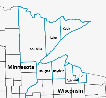
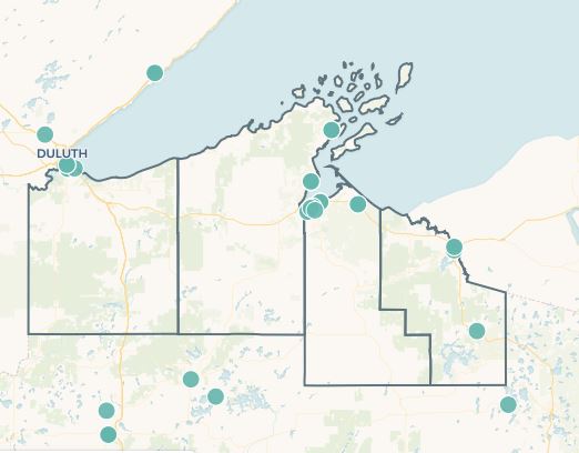
The main focus area of CHAOS is Western Lake Superior; however, the community of practice is open to all Lake Superior communities and strives to have representation from across the region, across disciplines, and all levels of government.
Minnesota & Wisconsin Western Lake Superior Coastal Counties:
Minnesota: St. Louis County, Lake County, and Cook County
Wisconsin: Douglas County, Bayfield County, Ashland County, and Iron County
Project Components
- Community of Practice: Meetings and field trips help keep the community informed and facilitate regular updates on efforts to protect the coasts of western Lake Superior.
- Monthly Newsletter: Regular communications to local communities, decision-makers, and private citizens about resilience tools and resources, training opportunities, funding opportunities, events, and more.
Coordinating Organizations
- Lake Superior National Estuarine Research Reserve
- Minnesota Lake Superior Coastal Management Program
- Minnesota Sea Grant
- National Oceanic and Atmospheric Administration
- Wisconsin Sea Grant
- Wisconsin Coastal Management Program
East River Collaborative
Overview
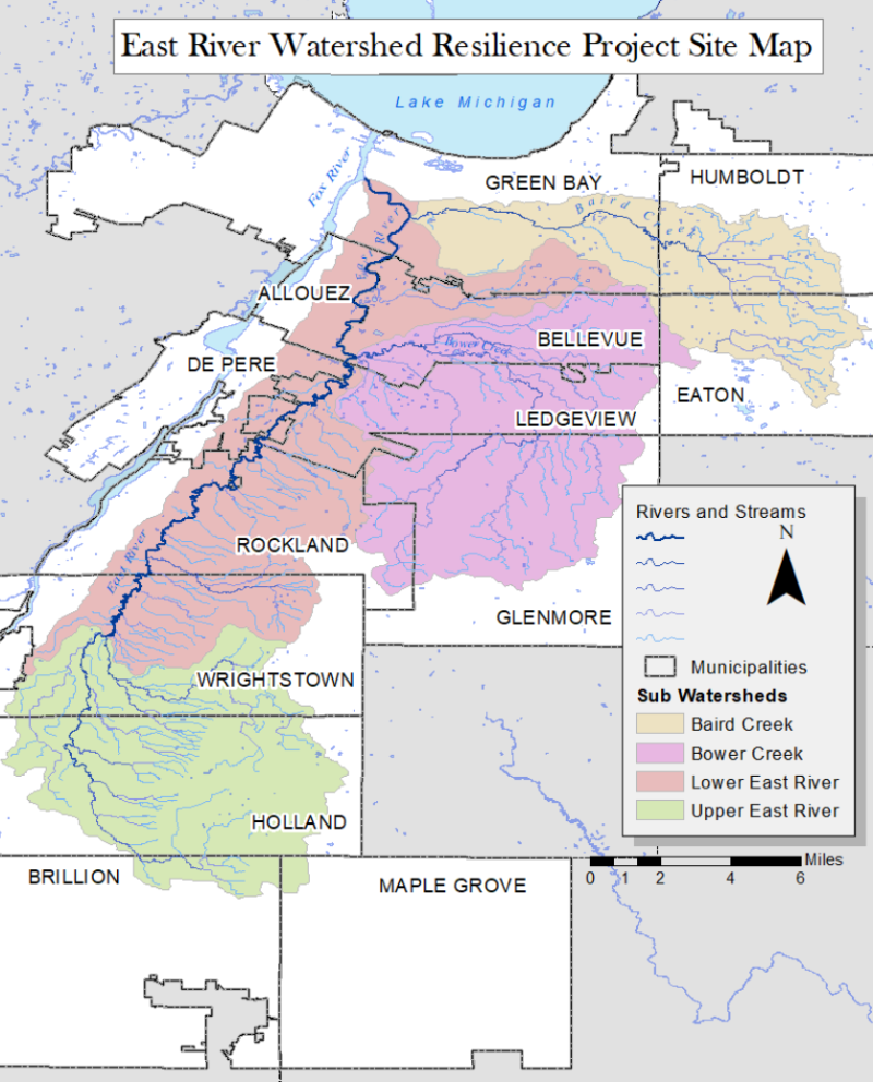
The East River Collaborative (ERC) is a community-driven approach to flood resilience planning in the East River Watershed, which is primarily in Brown County, Wisconsin.
Goal
The ERC brings local governments together with the goal of collectively achieving a common version of a more resilient, flood-prepared East River Watershed.
 Focus Area
East River Watershed
- City of Green Bay
- Town of Humboldt
- Town of Eaton
- Village of Bellevue
- Town of Ledgeview
- Village of Allouez
- City of De Pere
- Town of Glenmore
- Town of Rockland
- Village of Wrightstown
- Town of Holland
- Town of Maple Grove
- City of Brillion
- Brown County
Project Components
Community of Practice: Meetings and field trips help share flooding perspectives across the watershed and bring flooding expertise to stakeholders.
Flood Resilience Assessment: A framework to better understand the impacts of flood hazards in a community and identify opportunities to increase flood resilience.
Flood Scenario Modeling: New flood modeling analysis of extreme rainfall and Lake Michigan water level scenarios to guide the development of strategies to address flooding.
Coordinating Organizations
- NEW Water
- Wisconsin Sea Grant
- The Nature Conservancy
- UW-Madison Department of Civil and Environmental Engineering
Lake Michigan Coastal Resilience Initiative
Overview
The Lake Michigan Coastal Resilience Initiative aims to build capacity among Great Lakes municipalities to strengthen and respond to coastal zone challenges such as coastal erosion, flooding, and storm events. The Lake Michigan Coastal Resilience Initiative is a 2-phase project that provides support to Lake Michigan municipal leaders and natural resource managers. The Initiative ultimately develops engineering and design plans for site-specific, locally-driven, nature-based shoreline projects. This project will be expanded to other basins in the future.
Goal
To support the development of competitive, municipal-scale projects that incorporate the development of nature-based solutions in coastal areas and to support the habitat and species goals of the Great Lakes Restoration Initiative (GLRI).
Focus Area
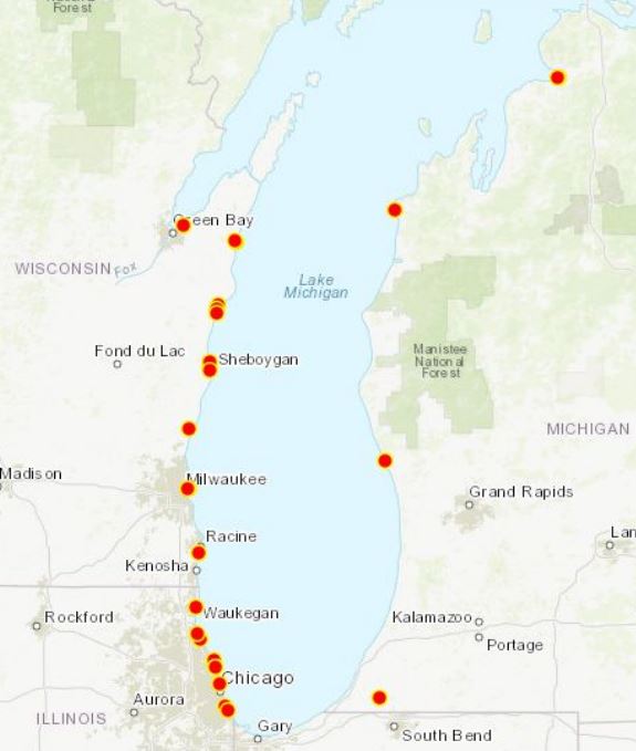
Lake Michigan municipalities in:
- Wisconsin
- Illinois
- Michigan
Project Components
- Phase 1 – Trainings & Workshops: Webinars to educate local officials on resources, tools, best practices, and engineering options for implementing nature-based infrastructure in coastal areas.
- Phase 2 – Municipal-Scale Projects: One-on-one technical assistance to refine municipal-scale project proposals aimed at addressing coastal resilience. Engineering and design plans to create “construction ready” projects are developed for selected proposals.
Coordinating Organizations
- Great Lakes and St. Lawrence Cities Initiative
- National Oceanic & Atmospheric Administration
Visit the Lake Michigan Coastal Resilience Initiative Webpage
Northeastern Wisconsin Coastal Resiliency Study
Overview
The Northeastern Wisconsin Coastal Resiliency Study works with coastal communities in Northeastern Wisconsin to examine their coastal hazards issues and identify opportunities to build resilience strategies into local planning efforts.
Goal
To advance the region’s ability to adapt to and withstand coastal threats.
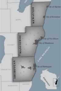
Focus Area
Coastal communities in:
- Sheboygan County
- Manitowoc County
- Kewaunee County
Project Components
- Achieving a Resilient Coast: A report summarizing Northeastern Wisconsin coastal hazard issues and needs, with a framework to help plan for resilience.
- Resiliency Portal: Information hub with educational resources, maps, data, funding opportunities, and a virtual field trip of the region’s coastal hazard issues.
Coordinating Organizations
- Bay-Lake Regional Planning Commission
- Wisconsin Sea Grant
Visit the Northeast Wisconsin Coastal Resiliency Study Website
Wisconsin Initiative on Climate Change Impacts
Overview
The Wisconsin Initiative on Climate Change Impacts (WICCI) is a statewide collaboration of scientists and stakeholders formed as a partnership between UW-Madison’s Nelson Institute for Environmental Studies and the Wisconsin Department of Natural Resources. The mission of WICCI is to generate and share information that can foster solutions to climate change in Wisconsin.
Goal
WICCI engages citizens, private and public decision-makers, and scientists from Wisconsin and the region in a collaborative network to (1) develop scientific understanding of climate impacts, (2) identify vulnerability to climate change and climatic variability, and (3) enable better adaptation activities.
Focus Area
State of Wisconsin
Project Components
- Climate Assessment Report: Explains the issues and impacts of our warming climate on Wisconsin residents and describes the scientific progress made toward solutions.
- Working Groups: A number of WICCI Working Groups explore how changing climate conditions will impact Wisconsin’s Great Lakes resources and potential solutions to these issues. These include the Coastal Resilience Working Group, Great Lakes Working Group, and the Infrastructure Working Group.
Coordinating Organizations
- Wisconsin Department of Natural Resources
- University of Wisconsin-Madison’s Nelson Institute for Environmental Studies
Wisconsin Coastal-Management Data Infrastructure Project
Overview
The Wisconsin Coastal-Management Data Infrastructure (WICDI) provides data, tools, and training to address regional coastal hazard mapping issues. WICDI has used culvert data to implement their cloud-based data infrastructure. At-risk culverts can be identified through inventorying and mapping which can help justify the need to upgrade or replace vulnerable infrastructure.
Goal
Provide the resources needed for coastal and culvert managers to quickly and appropriately respond to damages or identify vulnerable culverts before catastrophe and to increase flood resilience.
Focus Area
This project originally focused on Wisconsin’s Lake Superior coastal communities, but is currently expanding to include Wisconsin’s Lake Michigan coastal communities as well.
Project Components
- Community of Practice: Shared, cloud-based data infrastructure supports the work of the interdisciplinary community of practice. Land and water conservation departments, road and highway departments as well as those working on fish passage, storm water management, flooding, and water quality modeling need this information to make their models reflect the real world.
- Lake Superior Culvert Inventory Database: The culvert inventory database serves as an index of where road and stream crossings are present, who has inventoried the culverts and when, and what attributes they have collected. Anyone can use the database for mapping streams, lakes, and wetlands.
Coordinating Organizations
- Wisconsin Coastal Management Program
- Wisconsin Department of Administration
- Wisconsin State Cartographer’s Office
